Yes, on my android tablet, I can pair with it, and it shows it as a BLE device, but SW Maps doesn’t access it. If you download " Serial Bluetooth Terminal" from the Play store, this app can select BLE device and you can connect to it. Until SW Maps for android has a selection for BLE devices, I’m afraid we still have to use BT classic…
oK @splee,
Question: but in SW maps I see two BLE entries!? (ardusimple BLE and NMEA BLE). Also gnss master with the BLE option!? My problem is that it doesn’t pair with my cell phone!??
BLEEEEEE.pdf (100.2 KB)
Yes, I think your phone has to pair with BLE before you can even do anything. On my android tablet, if I delete the previous BT classic name, I see the TEST_RTK name when I scan and I can select it and it will pair as a BLE device. The symbol is different from BT classic. But then in SW Maps, when I select that device, it fails to connect. Keep trying to pair and see if you can succeed…
So I was able to get SW Maps to connect via BLE by selecting Ardusimple BLE Bridge as the instrument. However, it seems to disconnect every 34 seconds and NTRIP data doesn’t get sent to the board. This happens even if you use tomrm’s full code in a esp32. It works perfectly with iOS but apparently not with android. Try it with your phone with your esp32 bridge and make it connect via BLE instead of classic BT by changing the instrument and see what you see.
I think it must be something with how SW Maps handles BLE packets. If I connect to the module with Serial Bluetooth Terminal, using BLE, it connects fine and stays connected and the NMEA messages just keep scrolling up the screen. But with SW Maps, it disconnects after 34 seconds!
Hi @splee but unfortunately I wasn’t able to pair any device I had at home (S21 and Tab7 from Samsung).
I’m trying with an old hauwei cell phone (it’s charging now). Too bad the ble doesn’t work well with esp32-c3.
Thanks anyway for everything. Greetings
To be accurate, BLE works fine with iOS, it just doesn’t seem to work properly with android. But since BT classic works fine with android, that’s not a problem. It’s just a problem if you want to use your esp32-c3 with android… ![]()
@splee you are right “to sell” on the esp32c3 issue. The fact that Ble doesn’t work with Android is not a big problem also because the esp32-c3 modules cost me very few euros. I have this million dollar question (or in your local currency): among the various possibilities of connecting the GPS without direct connection via USB cable which, in your opinion and your experiences, is most efficient and stable among the following possibilities : 1) connection via Bluetooth bridge; 2) connection via wifi bridge; 3) connection using an external HC05 module connected directly to the TX and RX pins of the GPS.
Greetings and thanks
AF
A lot depends on what you’re trying to do.
For interfacing the GPS nearby to a phone or tablet app, I like the esp32 BT/BLE solution the best. You could use an HC-05 as well, but I like the esp32/Arduino combo a lot and use it for a lot for WiFi and BT projects.
If the GPS needs to be on the network, then I would use wired USB or WiFi (if it’s far away). For example, if you are implementing a RTK Base station and the GPS and antenna needs to be far up in the roof, then you could use a wifi bridge to reach it. Then you only need to run power up the roof. But you could also have a Raspberry Pi paired with the GPS via USB, and then use the Pi’s wifi to connect to the network.
Lots of options and things to try, whatever you’re trying to do.
BTW, I managed to get tomrm’s code to compile under esp32 V3.0.5 board library, if you are interested.
Needless to say @splee! Of course I’m interested in the version of Tomrm that works with the new 3.0.5 library. If possible also of your two versions: classic bluetooth only and the one for esp32-c3.
You got ahead of me in your questions: I was just thinking of asking you why it wasn’t possible to load the sketch with the new library. Also because every time I open the Arduino IDE I am “tempted” to accept the updates and replace the old library with the new one. Thank you very much for the answer to my question. Greetings
AF
I don’t want to post other people’s modified code without permission, so I am sending them to you via PM. Check your messages…
Well @splee I received and tried two sketches:
- the Tomrm bluetooth classic/BLE version;
- the BLE version for esp32-c3.
The first I would say is fine in the sense that the cell phone is associated (I have to solder some wires to my esp32 wroom to try with the data too).
The second version (Ble for esp32-c3) loads without problems but, unlike the previous version, I don’t see the existence of the Bluetooth signal (I don’t see the device) and therefore I can’t even attempt to pair with my mobile phone or android tablet.
Sorry for the late response but the forum is “punishing” me because I have too much activity
Thanks so much again.
Greetings and have a good day.
Well, not to waste any more time on the C3 version, but try loading the app Serial Bluetooth Terminal below. In the settings for devices, you can see both Classic and BLE devices on seperate tabs, and you can even pair from there.
I apologize @splee because perhaps I didn’t express myself correctly.
I sent you the info on the esp32-c3 sketch for your feedback but I’m no longer interested in the C3 modules!.
I am already more than satisfied to have finally solved the connection between LG290P and the mobile phone via Bluetooth of the wroom esp32 modules.
Thanks again for everything!
Greetings
AF
Yes, I did understand, but sometimes I pursue things for the sake of it! ![]()
More importantly, why are you posting at 4:30am in the morning?
Sorry, I am loosing it, I miscalculated your time…
7:20 am
Don’t worry @splee! I don’t rule out having sent messages at absurd times: I sleep little and badly!
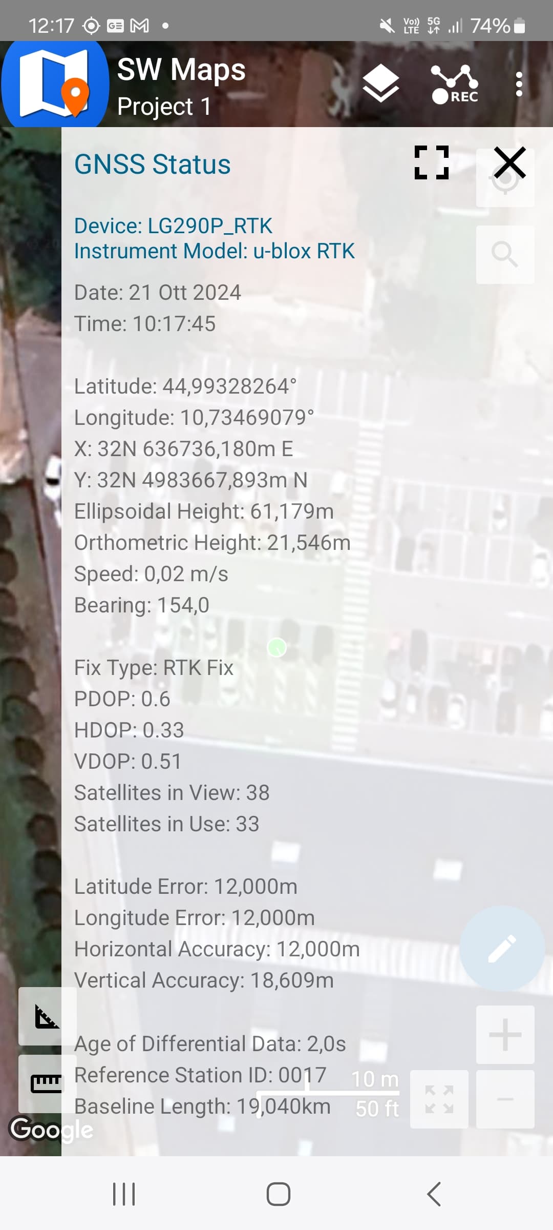
But I would rather have this question: why in sw maps do these four parameters (latitude error, longitude error, horizontal accuracy and vertical accuracy) have the value N/A?
Good day
AF
I have wondered about that too. I’m no GPS expert but perhaps @bamarcant knows.
I know that no accuracy values show up in QGNSS either so the module is apparently not outputting that data. Maybe there is an option but I couldn’t find it. All they provide is PDOP and HDOP, which is a good indication of quality as well.
I know the other brand of module does provide that information as it shows up in their program, but it’s probably in their proprietary format and SW Maps doesn’t show it either.
I correct myself @splee, in fix mode I read the parameters latitude, longitude, etc. etc. in SW maps. but with values of several meters (12-18 meters - see photo)!??.
I also see that the SW maps time is 2 hours late compared to the actual time (summer time in Italy).
Greetings
AF
How did you get that to display? On both android and iOS, I get N/A, even with RTK Fix.
The time on android is UTC time. On iOS, they provide both local time as well as UTC time.
I didn’t do anything extra. I just set LG290P as rover.
At the beginning, when I connect via Bluetooth to the GPS module, the software indicates the “N/A” situation, then over time the parameters are read in SW maps. The problem is that they are several meters! I just tried with my LC29HEA module and with that too I see the parameters latitude, longitude etc. etc.
I use SW Maps 2.10.1.0 dated May 6, 2024.
I also see that the Arduino IDE has updated to the new esp32 expressif ver. 3.0.6.
I just reinstalled the sketch and luckily it also works with the new library!? What will I do in a few years…?
I add: today is not my lucky day. I had just received the new LC29HDA module but with a clumsy operation on my part it was fried in a pan (I don’t want to go into details).
This time I’m sure I ruined the form because I smelled that little smell of burnt plastic… Yet you warned me to be careful!
Greetings and thanks for your interest
AF