Thanks for your answer mr Stone!
About the satellite clock offset:
To give more context, we’re trying to get the position of our sensor by Code Base Positioning by using satellite data. A brief explanation of this method can be found here: https://gssc.esa.int/navipedia/index.php/Code_Based_Positioning_(SPS)
However, one of the variables that we’re missing is in equation #2 in the previous link is the satellite clock offset (see next line after the equation (2) in the previous link, where Dj = …+…+…).
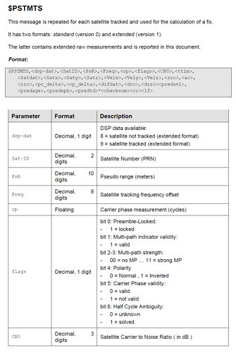
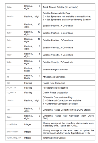
So when it comes to the satellite clock offset, where in the PSTMTG data can I find the satellite clock offset? Also, how can I correlate it to certain satellite IDs (or PRN)?
- About switching to RTCM protocol:We used Teseo Suite for sending commands to the L26-P. We used the following sequence of commands to convert NMEA to RTCM found in this forum:
$PSTMSETPAR,1227,9,2
$PSTMSAVEPAR
$PSTMSETPAR,1227,20020,1
$PSTMSAVEPAR
$PSTMSRR
In NMEA format the messages looks like:
$GPRMC,103517.000,A,5149.18761,N,00445.86316,E,0.1,0.0,270241,D66
$GPGGA,103517.000,5149.18761,N,00445.86316,E,2,08,0.8,021.69,M,47.2,M,6C
$PSTMTG,3190,297334.99958060,8,277891418,9,-45849.4160,902a,125557.717767,125422.614,277891846,277891846,129,0,0,7,3190,297334.999581,9,3190,297320.999581,105D
$PSTMTS,9,161,32733362.312,41964.94,140136539.074,83,53,245471,0,0.00,0.00,0.00,0.00,0.00,0.00,0.00,0.00,0,-5821614.033,-1.977,0,0.00,0.00,13,790,13,028
$PSTMTS,9,165,30305784.188,45841.56,127495378.348,83,34,243859,0,0.00,0.00,0.00,0.00,0.00,0.00,0.00,0.00,0,-5821614.465,-0.355,0,0.00,0.00,300,1784,16,021
$PSTMTS,9,175,30110353.875,48032.80,126477841.695,83,46,243499,0,0.00,0.00,0.00,0.00,0.00,0.00,0.00,0.00,0,-5821614.710,0.559,0,0.00,0.00,-20,893,12,023
$PSTMTS,9,13,30884663.812,-46315.64,-131707125.758,83,33,219737,1,-14093094.47,5437004.41,21703588.62,-631.19,-2714.51,282.35,47229.91,28.34,1,-5821614.471,-0.191,14,-27.38,0.00,134,2238,15,01F
$PSTMTS,9,30,7032347.062,-44572.03,-6362444.020,50,14,45231,1,-10859993.72,-11496243.62,21397125.75,1814.86,-2015.19,-185.84,-135089.28,22.22,-1,-5821614.278,0.531,14,-21.08,0.00,-92,35872,113,036
$PSTMTS,9,145,45981844.938,45436.10,209124865.391,83,36,202854,0,0.00,0.00,0.00,0.00,0.00,0.00,0.00,0.00,0,-5821614.420,-0.523,0,0.00,0.00,0,3218,95,0*2C
However the messages received through serial UART communication are as follows:
b’\xd3\x00\x99CP\x01]>\xbaB\x00\x00z@R\x00\x00\x00\x00\x00 \x00\x00\x00\x7f\xd4\x80\x92\x11\x11\x91\x93\xd2\xd3\xc0\x00\x00\x00\x02\xd3\x0e\xbc\x11\xca\xe2\xa2\xa4\\xb0\x9d\x0b\xbb\xdc0y\xc0*\xfb+\xe5\x90\x97\x02\t\t\x10@\xbd\xcb\xa1\xb3\xf3\xf4\xb8\x08H\x87\xc3\x8cts\xe0\x99L\x03\xa7Zi\xc1\x14c\xc2\xe7\xe9\x7f\x93\x1d}\x8e\xd5\x82]\xec\x02\xec\xe0\xbf\x82\x88B\xf1\xad}7l\x9c\xc0\x01am\x1e\x07\x81rx\x1e\x04\x04\xb2\x91?\x93\x8c9F\xc3t\x8c Ig\xfa\xd70\xce\xdca-\x89#\x81\xc7#\xf7\xb6\xc0\xcd$-\xd3\x00\x8bC\xf0\x01\x8dk\x0f\x02\x00\x00A\xc0\x83\x80\x00\x00\x00\x00 \x00\x00\x00\x7f\xa5!\xa0\xa5\xa5% \x85\xc6j\xb2T\xfe\xe9\xda\xaa\xf2:Y>\xb9n\xfa\xea\rW\xe5>\xee\x00\x8c\x19\xf0\x07>\xeex\x1d\xb0\xefs\x11\xb0\x1e3\xcd\xffB\x7f2\xcc\xe9\xe3v\xa7\xe0~\x01\xf0\x83\xbdj\x03\x97\x19\xf7\x9az\xff\xcfS|\x8em\xfaxl\xfa\x9d&\xa9\x80\x03<\xc0\x00\x05\xf0\x00\x00\x00\xb9\xa8{\xe7\n’
b’\xa2.\xaa\xf0\x92\x88{\xef\xc5\xce(\x8c\x81\x03\xb0\t\xbf]\xfa\xd2\x00\xe0#!\xd3\x003D\x90\x01]>\xba@\x00\x00\x08\x00\x10\x00\x00\x00\x00\x00\x04\x00\x00\x00ji\xc0\n’
b’0\x83\xf3\x98\x13\x9b\xdc\xfez\x10\x9e\xf7\x0c\xe1\xe8\xbc\x0e\x0b,\xd2\x8e\x10\xd2\xde\xfb\x00\xb6\xd6\x8c\xd3\x00\x15>\xe0\x01\x03\x08\xf2\xba\xa7\xb1\x80\xbd\xf9\xd8\x96\x0b\xc9\xf0\xcal\x00\x00\xc3A\xe6$PSTMDRSENMSG,30,549728056,-2915,5264,15445*02\r\n’
The messages from the sensor are still the same as in the NMEA format:
$PSTMDRSENMSG,31,277946015,94,-87,-119*25
Teseo suite cannot decode this message in satellite information, did we convert the message correctly?
Also, we do not have a protocol specification for the latest firmware, so we are highly dependent on asking questions and being lucky on this forum finding answers. How can we get the full protocol specification for the current firmware? It might prevent us asking a thousand questions  If you want to send a document please send to info@parsectiming.com !
 If you want to send a document please send to

