Hi,
I am not able to open the configuration view in the QGNSS Software.
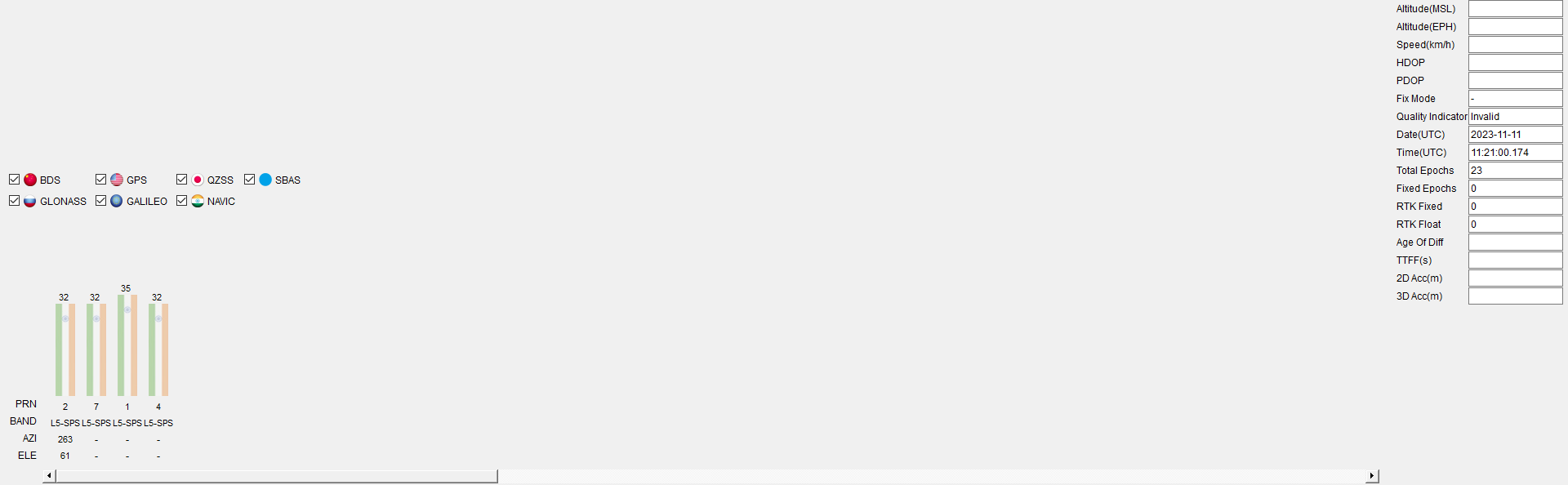
The L89HA module claims to receive GLONASS and BEIDOU GPS Data as well, however I dont see any satellite for the same.
I also want to configure the L89HA for a higher Update Rate, but cannot do.
I am using the QGNSS V1.9
This is what I get when I power up (contains the firmware version)
F1: 0000 0000
V0: 0000 0000 [0001]
00: 0000 0000
U0: 0000 0001 [0000]
T0: 0000 00B2

Leaving the BROM
$PQTMVER,MODULE_L89HANR01A06S,2022/07/28,18:27:04*7A
$PQTMVER,SUB_V01*39
$PAIR001,002,1*38
$PAIR001,021,0*38
$PAIR021,AG3335M_V2.2.0.AG3335_20220728,S,I,f7989b9,2207181550,,,,,6a78118c,2207181542,4b87ec2,2207181548,,,,,-15.48,-15.48,-14.02,-15.48,0,1,#P,0,255*0F
$PAIR011,001*27
$PAIR010,1,-1*16
$PAIR010,2,-1*15
$PAIR001,002,0*39
$PAIR001,021,0*38
$PAIR021,AG3335M_V2.2.0.AG3335_20220728,S,I,f7989b9,2207181550,,,,,6a78118c,2207181542,4b87ec2,2207181548,,,,,-15.48,-15.48,-14.02,-15.48,0,1,#P,0,255*0F
This is a sample packet the module.
$GNRMC,101536.000,A,xxxx.xxxxxx,N,yyyy.yyyyyy,E,0.10,66.24,111123,,,D,V*##
$GNGGA,101536.000,xxxx.xxxxxx,N,yyyy.yyyyyy,E,2,21,0.63,925.361,M,-88.293,M,,*##
$GNVTG,66.24,T,,M,0.10,N,0.18,K,D*18
$GNGSA,A,3,04,08,09,27,03,199,194,07,196,16,195,,1.18,0.63,1.00,1*00
$GNGSA,A,3,08,30,27,07,03,02,,,,,,,1.18,0.63,1.00,3*07
$GNGSA,A,3,03,09,06,10,,,,,,,,,1.18,0.63,1.00,6*07
$GPGSV,4,1,16,04,71,047,21,40,59,241,28,08,55,122,36,09,50,339,36,1*6D
$GPGSV,4,2,16,27,35,067,43,03,34,193,18,199,32,101,33,194,23,050,33,1*6E
$GPGSV,4,3,16,07,23,313,28,196,17,134,16,16,16,033,22,14,14,233,22,1*52
$GPGSV,4,4,16,195,10,098,25,21,09,149,19,02,09,157,16,30,04,290,15,1*50
$GAGSV,3,1,09,08,72,073,26,30,64,338,19,27,39,247,31,07,39,334,17,7*77
$GAGSV,3,2,09,03,29,128,27,02,23,031,16,15,08,172,,34,02,125,16,7*77
$GAGSV,3,3,09,13,01,219,,7*43
$GIGSV,2,1,08,03,74,157,27,09,64,251,34,02,60,244,18,04,54,065,,1*73
$GIGSV,2,2,08,06,37,261,36,10,31,095,40,07,29,101,41,01,,,28,1*4E
$GNGLL,xxxx.xxxxxx,N,yyyy.yyyyyy,E,101536.000,A,D*##
$PQTMANTENNASTATUS,1,0,1*4F
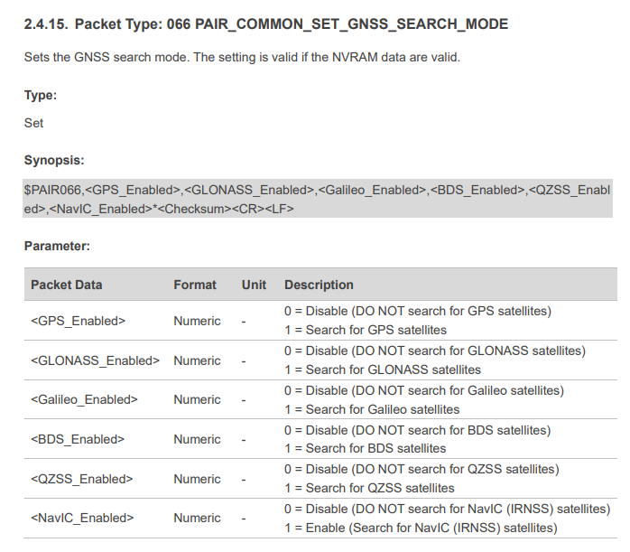
How do I enable position data only from the IRNSS satellites, How do I configure other parameters from the tool (not by sending individual commands). In fact I dont see the SBAS Satellites too… ![]()
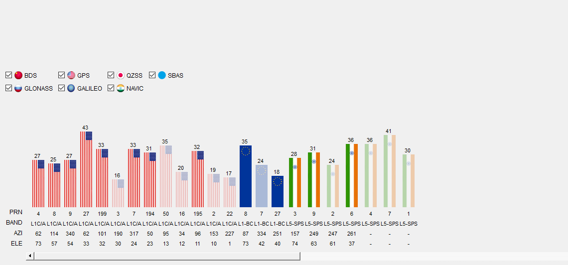
Also when I send $PAIR066,0,0,0,0,0,1*3B to get only the IRNSS signal, I dont get any position fix.
Please help